LVMS Driftbox and Google Earth
- Thread starter BlackICE
- Start date
You are using an out of date browser. It may not display this or other websites correctly.
You should upgrade or use an alternative browser.
You should upgrade or use an alternative browser.
H
HHGT
Guest
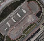
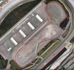
The 1st picture is the line I took around the track. The 2nd photo is Mark McGowan's drifting line.
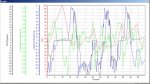
Does the Driftbox output KML directly or did you convert it? What is the positional accuracy? I found out early on with Google Earth that their rendering engine was single precision with a correction for shift. Please elaborate, inquiring minds want to know!
Nice job BTW
The Driftbox software exports to a KML file that Google Earth reads. You can make adjustments in X,Y offsets if needed. I didn't do any adjustments. I found the accuracy better than I expected. The last time I look into this I recall that GPS had a +-8' accuracy, with best case a little over a meter.
H
HHGT
Guest
The Driftbox software exports to a KLM file that Google Earth reads. You can make adjustments in X,Y offsets if needed. I didn't do any adjustments. I found the accuracy better than I expected. The last time I look into this I recall that GPS had a +-8' accuracy, with best case a little over a meter.
I often thought it would be an excellent real-time learning race-aid to have a direct feed from a device like driftbox plot the data in real-time over a Google Earth (or preferably Google Map) on a handheld and then generate a report to let the driver know when he entered and exited an apex. You could arguably have the GPS even plot points of interest and time deltas between certain points to aid in late/early breaking etc. A driver could pull in between runs to evaluate his last run and adjust accordingly for the next run. Further, you can have different profiles available for different cars and provide audio alerts during a run. My mind is racing with ideas. Hmmmm, I wonder if there is a big market for this?
Team Jeff
GT Owner
- Sep 8, 2007
- 559
I often thought it would be an excellent real-time learning race-aid to have a direct feed from a device like driftbox plot the data in real-time over a Google Earth (or preferably Google Map) on a handheld and then generate a report to let the driver know when he entered and exited an apex. You could arguably have the GPS even plot points of interest and time deltas between certain points to aid in late/early breaking etc. A driver could pull in between runs to evaluate his last run and adjust accordingly for the next run. Further, you can have different profiles available for different cars and provide audio alerts during a run. My mind is racing with ideas. Hmmmm, I wonder if there is a big market for this?
I have used the Traqmate unit with good success...
http://traqmate.com/
Nice guys there too.
H
HHGT
Guest
Thanks!